- Home Page /
- Electronics /
- Camera /
- Camera Tripods & Monopods /
- Complete Tripods /
- PPK, NOAA RTK GNSS Survey Equipment GPS Recei...
0 ratings

Item #:
143127275
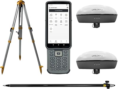
PPK, NOAA RTK GNSS Survey Equipment GPS Receiver with IMU Rover & Base Handheld Collector Land Surveying Equipment, Survey SoftwareInclude Pole,Tripod
Item #:
143127275
PKR 844084
Price Details
Excluding Shipping & Custom charges ( Shipping and custom charges will be calculated on checkout )
*All items will import from US
0 ratings
Write a review
In stock
 Imported from USA store
QTY:
Order now and get it around Saturday, July 18
Secured transaction
Ubuy works hard to protect your security and privacy. Our advanced payment security system ensures confidentiality by encrypting your information during transmission using AES (Advanced Encryption Standards) and SSL (Secure Socket Layer) protocols. Your payment details are 100% secure as we do not share your payment details with third party sellers.
Our Top Logistics Partners


Unsurpassed Precision: Our RTK technology ensures centimeter-level accuracy, providing you with reliable measurements for the most demanding surveying tasks.

Fast
Shipping

Free
Return*

Secure Packaging

100% Original Products

PCI DSS Compliance

ISO 27001 Certified


Note: Step Down Voltage Transformer required for using electronics products of US store (110-120). Recommended power converters Buy Now.


What Stands Out
Precision GNSS
Utilizes NOAA RTK technology for high-accuracy land surveying, minimizing errors in data collection, making it ideal for professionals requiring exact measurements.
Integrated IMU
Includes an Inertial Measurement Unit for enhanced stability and accurate positioning in challenging environments, significantly improving survey results over traditional methods.
Comprehensive Package
Complete solution with GPS receiver, handheld collector, pole, tripod, and survey software, providing everything needed for effective land surveying in one convenient package.
Product Details
| Item Weight | 7.2 lbs (3.27 kg) |
Who Should Buy?

-
Professional Surveyors
Ideal for experienced surveyors needing precise location data for large land projects with high accuracy requirements.
-
Geospatial Engineers
Great for geospatial engineers working on mapping and designing infrastructure projects requiring advanced GNSS technology.
-
Agricultural Planners
Beneficial for agricultural planners looking to optimize land use and crop monitoring with reliable GNSS support.

-
Casual Users
Not suitable for casual users needing simple location data, as it offers complex features not necessary for basic use.
-
Budget-Conscious Buyers
High price point may deter budget-conscious buyers who can't justify the investment for occasional projects.
-
Hobbyist Surveying
Amateur or hobbyist surveyors may find this equipment overly complex and advanced for their basic surveying needs.
Product Description
PPK, NOAA RTK GNSS Survey Equipment GPS Receiver with IMU Rover & Base Handheld Collector Land Surveying Equipment, Survey SoftwareInclude Pole,Tripod
Have any Query? Chat with us
Customer Questions & Answers
-
Question:
What is the PPK NOAA RTK GNSS Survey Equipment?
Answer: The PPK NOAA RTK GNSS Survey Equipment is a GPS receiver designed for precise land surveying. It combines a rover and base station setup, providing accurate positioning data. Ideal for professionals needing reliable geographic information.Category: overviewConfidence: high -
Question:
What are the main features of the PPK NOAA RTK GNSS Survey Equipment?
Answer: The equipment features an integrated IMU for enhanced positioning accuracy, a handheld collector for field data capture, and robust survey software. It is optimized for land surveying applications.Category: overviewConfidence: high -
Question:
How do I set up the PPK NOAA RTK GNSS Survey Equipment?
Answer: To set up the equipment, first ensure the base station is connected to a power source and properly positioned. Then, calibrate the rover and connect it to the handheld collector as per the user manual. Follow the software instructions for final setup.Category: setupConfidence: medium -
Question:
What are the power requirements for the PPK NOAA RTK GNSS Survey Equipment?
Answer: The equipment requires a stable power source for both the rover and base station. Check the specifications in the user manual for exact voltage and battery requirements.Category: powerConfidence: medium -
Question:
What accessories are included with the PPK NOAA RTK GNSS Survey Equipment?
Answer: Included accessories typically consist of the rover unit, base station, handheld collector, mounting hardware, and necessary cables. For a complete list, refer to the product packaging or user manual.Category: accessoriesConfidence: medium -
Question:
How do I maintain the PPK NOAA RTK GNSS Survey Equipment?
Answer: Regular maintenance includes ensuring the devices are clean and free of dust, checking connections, and performing software updates. Refer to the user manual for detailed maintenance instructions.Category: maintenanceConfidence: medium -
Question:
Is there a warranty for the PPK NOAA RTK GNSS Survey Equipment?
Answer: Yes, the PPK NOAA RTK GNSS Survey Equipment typically comes with a manufacturer's warranty covering defects in materials and workmanship. Check the warranty details provided with your purchase.Category: warrantyConfidence: medium -
Question:
What should I do if I encounter a problem with the PPK NOAA RTK GNSS Survey Equipment?
Answer: If you encounter any issues, refer to the troubleshooting section of the user manual for guidance. Common solutions may include restarting the equipment or checking software settings.Category: troubleshootingConfidence: medium -
Question:
What is the operating range of the PPK NOAA RTK GNSS Survey Equipment?
Answer: The operating range can vary based on environmental conditions but typically supports accurate positioning within several kilometers, depending on the setup and surrounding obstacles.Category: specsConfidence: medium -
Question:
Can the PPK NOAA RTK GNSS Survey Equipment be used with other software?
Answer: While the equipment comes with dedicated survey software, it may also support integration with other compatible surveying applications. Check the specifications or contact the manufacturer for compatibility details.Category: softwareConfidence: medium -
Question:
How do I clean the PPK NOAA RTK GNSS Survey Equipment?
Answer: To clean the equipment, use a soft, dry cloth to wipe down surfaces. Avoid using harsh chemicals or abrasive materials to prevent damage.Category: cleaningConfidence: high -
Question:
Where can I buy the PPK NOAA RTK GNSS Survey Equipment?
Answer: The PPK NOAA RTK GNSS Survey Equipment can be purchased through official distributors or on various e-commerce platforms. Check local listings for availability in your region.Category: shippingConfidence: medium -
Question:
What are the specifications of the PPK NOAA RTK GNSS Survey Equipment?
Answer: Specifications may include GPS accuracy levels, the frequency of signals received, and battery life. For detailed specifications, consult the product user manual or official product page.Category: specsConfidence: medium -
Question:
What differentiates this model of PPK from others?
Answer: This model of PPK NOAA RTK GNSS Survey Equipment features advanced IMU integration and enhanced data processing capabilities compared to previous versions. Specific differences can be found in the technical specifications.Category: otherConfidence: medium -
Question:
What safety precautions should I take when using the equipment?
Answer: When using the PPK NOAA RTK GNSS Survey Equipment, ensure you follow general safety guidelines such as maintaining awareness of your surroundings, avoiding wet conditions, and not exposing the equipment to extreme temperatures.Category: safetyConfidence: medium
SMAJAYU Complete Tripods Editorial Review
No editorial reviews found
Customer Reviews & Ratings
1 customers ratings
-
5 Star
0%
-
4 Star
100%
-
3 Star
0%
-
2 Star
0%
-
1 Star
0%
Review this product
Share your thoughts with other customers
Platform Trust & Buyer Confidence

MT
Mohd
Verified buyer
“The product received very good packaging & safe…Thank You”
16 June 2026 · via Trustpilot
SJ
Shawati
Verified buyer
“Accurate delivery timing given”
16 June 2026 · via Trustpilot
YB
Youcef
Verified buyer
“Not madly expensive like I thought, and much quicker than promised.”
15 June 2026 · via Trustpilot
LM
Leila
Verified buyer
“Never dealt with Ubuy before, but everything worked out great. Seamless cross border purchasing and shipping. Thanks!”
6/7/2026 · via Trustpilot
KA
Kwame
Verified buyer
“The process was smooth, with clear communication and timelines. This was my 1st purchase and I am really impressed. I will definitely be coming back.”
12 June 2026 · via Trustpilot
Secure Checkout
Global Delivery
Easy Returns
Genuine Products
Product Price History
Important information
- Limitations : For products shipped internationally, please note that any manufacturer warranty may not be valid; manufacturer service options may not be available; product manuals, instructions, and safety warnings may not be in destination country languages; the products (and accompanying materials) may not be designed in accordance with destination country standards, specifications, and labeling requirements; and the products may not conform to destination country voltage and other electrical standards (requiring use of an adapter or converter if appropriate). The recipient is responsible for assuring that the product can be lawfully imported to the destination country. When ordering from Ubuy or its affiliates, the recipient is the importer of record and must comply with all laws and regulations of the destination country.
- Not all the products listed on Ubuy are for sale, as Ubuy is a global search engine. Products are subject to export/trade regulations.
PKR 844084
Order now and get it around Saturday, July 18
This item is not restrict in my country.(Please click on above link if this item is not restrict in your country, So our team will review and allow.)
QTY:
Secured transaction
PCI DSS compliant and ISO 27001:2022 certified, with encrypted payments and full buyer protection on every order.
Our Top Logistics Partners
Fastest cross-border delivery
Features & Benefits
- Achieve centimeter-level accuracy with advanced RTK technology.
- Ideal for topographic, geographic, engineering, and agricultural surveying.
- NOAA certified for reliability and performance.
- PPK capability allows for operation in challenging environments up to 25km.
- Supports multiple constellations for versatile applications.
- Data output compatible with various formats for easy integration.
Ubuy Assurance
Experience worry-free shopping with 100% original products, PCI DSS-compliant payment security, ISO 27001-certified data protection, the fastest cross-border delivery, free returns *, and secure packaging on every order.